

The information will be provided by the local authorities, in addition, the application will adapt the information according to day of the week, time, holidays, and payment methods
With information from Capufe, Google Maps will be able to show an approximate cost of tolls to enhance a trip.
Although it has its charm, taking a road trip requires better planning, from the routes that will be taken to reach the destination to the cost of tolls; For this reason, Google Maps will now show how much the toll booths charge within its application.
According to Google, the information on these costs will be provided by Caminos y Puentes Federales (Capufe), so that the users of the application can better plan their budget .

The new feature will be available for both Android and iOS users from October 14. In addition to Mexico, other countries such as Argentina and Brazil will also receive this update.
What are the toll booths near CDMX?
If what you want is to get away from the hustle and bustle of the city, you will most likely have to use one of the toll roads that connect CDMX with the neighboring states, be it Morelos, Puebla, Querétaro, Hidalgo, or the State of Mexico.
Although in all cases there are federal roads that do not charge tolls, toll roads are generally the fastest way to travel between entities.
To the north, if you travel towards Querétaro –or venture towards the Bajío states– you will come across the Tepotzotlán toll booth, and later the Palmillas toll booth, both on the Mexico-Querétaro highway.
Likewise in the north, but in the municipality of Ecatepec, Edomex, you will have to cross through the Ojo de Agua booth if you go towards Hidalgo; in this case, you will not find another toll crossing until you reach the city of Pachuca.
If your destination is the state of Morelos and you do not want to use the meandering freeway, then you must cross through the toll booth of the Mexico-Cuernavaca highway.
As for the east, depending on how long your trip is, you can use the Mexico-Texcoco highway to reach this municipality in the State of Mexico or take the road to the pyramids of Teotihuacán.
However, if you decided to take a longer route and reach the state of Puebla, you will have to cross the San Marcos booth to take the highway that connects CDMX with “the city of angels”.
How will it work?
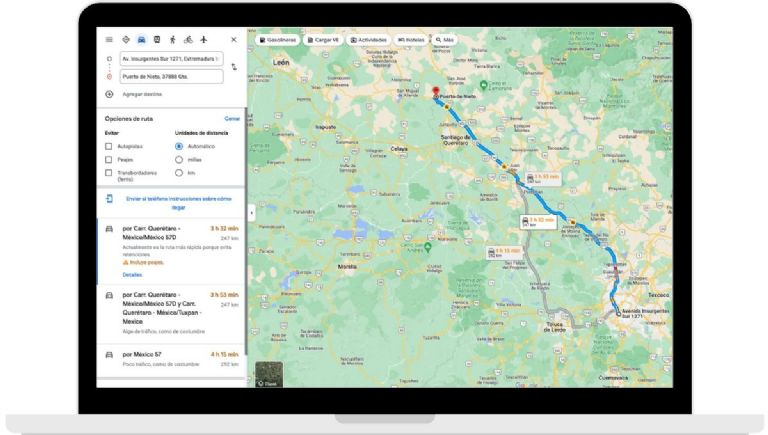
Currently, the application and the web version of Google Maps have a section entitled “directions”. In it, you can manage the best route for navigation, car, and public transport; on foot, by bicycle, and even by plane! Now this new function that came to complement the tool will tell you if there are booths in your transfer and will show the rates in real-time.
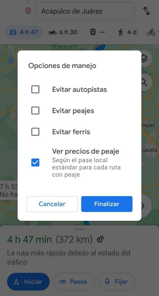
According to the most used search engine in the world, Maps will concentrate all the information from local authorities, thus showing reliable information that helps create approximate expenses without the need to use or collect data from third parties. Google added that it will give rate estimates according to factors such as the day of the week, the time, special occasions such as holidays, and, finally, payment methods.
Collection of booths
Currently, Mexican highways receive cash or use a tag. This is a sticker, device, or card that helps you navigate the roads without the need for a physical transaction. In the country, there are IAVE-Electronic Highways and Federal Bridges (Capufe) and Televía, which are the only ones that provide the service, and its price ranges from 150 pesos and up, depending on the service.
Benefits
Google added that they will also show alternate routes or routes so that the user does not have to pay a fee and access the “free roads”, whenever there is one available. To view it, all you have to do is select the option to “avoid tolls” every time you mark the destination. The function is found in the three dots in the upper right corner in the app and in the web in the three lines on the left side in the “Options” section.

It should be noted that this new way of viewing booths in the country is now available for both Android and iOS starting today. This update is also shown in the web version , however, details such as costs in Mexican pesos need to be refined. They added that countries like Brazil and Argentina will be the few that can also enjoy this new function in their respective countries.
In addition, as part of its new functions, Google Maps will show you an alternative route where you do not have to pay a fee, whenever there is a free route available.
To access this alternative, you only have to select the option ‘Avoid tolls’ once you have marked the destination.


